|
YOSTS (THE NOSES).
(Montgomery County)
(Over N.Y.C.R.R. , N.Y. 191 m.; Buff., 235 m.; sea level elevation, 286 feet.)
Yosts Mileage Distances, Mohawk Turnpike, New York-Buffalo Highway.
Eastward: Fonda, 6 m., (by detour north from Fonda) Johnstown 10 m., Gloversville 14 m.,
Auriesville Shrine 9 m., Tribes Hill 12 m., Fort Johnson 15 m., Amsterdam 17 m., Schenectady 33 m., Albany
48 m., New York 197 m.
Westward: Canajoharie-Palatine Bridge 6 m., (by detour north from Palatine Bridge) Stone
Arabia churches 10 m., Fort Plain-Nelliston 9 m., Palatine Church 12 m., St. Johnsville 15 m., (by detour to
south shore road from St. Johnsville) Gen. Herkimer Homestead 23 m., East Creek 18 m., Fink's Basin Bridge (Fall
Hill) 23 m., Little Falls 25 m., Herkimer 32 m., Mohawk 33 m., (by detour from Mohawk) Fort Herkimer church
35 m., Ilion 37 m., Frankfort 39 m., Utica 49 m., Whitesboro 53 m., Oriskany 56 m., Oriskany Battlefield
Monument 58 m., Rome 64 m., Syracuse 99 m., Buffalo 253 m.
Yosts is a railroad station only, serving the surrounding country. It takes its name from
the Yost family (of Holland descent), pioneer settlers of the neighborhood. A ferry (which has been in operation
for probably two centuries) connects with Randall (formerly Yatesville) , a hamlet on the south Mohawk shore,
opposite Yosts. A bridge, across the Mohawk, was constructed here in 1825 but was carried away by the ice
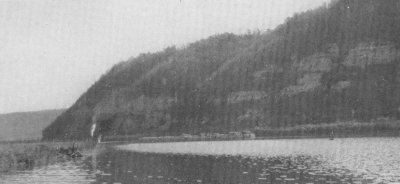
shortly after and never rebuilt. Yosts and Randall lie just to the east of the lower uplift of the Mohawk,
known as the Noses. The upper uplift is at Fall Hill (Little Falls). Yosts lies at the base of the Big
Nose (sea elevation, 940 feet) and Randall lies at the base of a spur of the South or Little Nose
(sea elevation, 820 feet).
Barge Canal Lock No. 13, Dam No. 9.
From the nearby hotel, at Yosts, the interesting traffic of the Mohawk river can be seen
passing through the beautiful river country of the Noses. A Barge canal lock and dam is located in the river
here, rising 8 feet from 278 feet sea level below to 286 feet sea elevation above the dam. This is Lock No. 13,
Dam No. 9 of the State Barge canal, also known as the Yosts lock and dam. The level runs west to Canajoharie dam,
over 6 miles.
Dockstader Tavern, 1775 -- Big Nose Mountain Inn.
The Big Nose Mountain Inn is built around the old Dockstader turnpike Inn, which was built
by Hollander pioneers, before 1775, on the King's Highway, which was the Colonial name of the north side road.
The Noses, 654, 534, 414 Feet Above the Mohawk.
The bold, wild bluffs rising to the west and north, from Yosts, have been known as The Noses
from the earliest times, taking the name from their supposed resemblance to the human nose. There are three chief
summits. The Big Nose, west of Yosts, is the highest with a sea elevation of 940 feet, and an elevation above the
Mohawk of 654 feet. Almost opposite on the south shore, is the Little Nose, which rises in a sheer height 380 feet
directly above the Mohawk. This is the highest cliff west of the Highlands of the Hudson. The Little Nose (sometimes
called Anthony's Nose) has a total summit elevation above the Mohawk of 414 feet, and a sea elevation of 700 feet. The
South Nose spur or Wasontha Hill extends along Wasontha creek. It has a sea elevation of 820 feet and a river elevation
of 534 feet. The Noses and the river country adjacent thereto form one of the most beautiful landscape features of the
Mohawk valley.
Nose Ridge is severed here by the pass of the Mohawk. The Little Nose section slopes gradually
and is lost in the uplands of the southern central Mohawk river valley plateau, a few miles south of the river.
In this respect, Nose Ridge is unlike Fall Hill and Yantapuchaberg - Touareuna, which are mountain ridges forming
connecting links between the Adirondacks on the north and the Catskills on the south.
The views to be obtained from all three of the Nose summits are well worth the trip on foot. The
scenery of the valley should be seen from the river roads, the uplands and the hill and
mountain summits, like those of the Noses.
The general surface rock along the river (from Fonda to Canajoharie) is of the lower Silurian
calciferous Trenton limestone, but there is a considerable outcrop of gneiss at the Noses. An interesting feature
of the south Mohawk shore near the Noses was the discovery here of a small natural gas well in 1915. It burned itself
out in several months. There are small pockets of natural gas in many valley localities, particularly on the south
shore.
In the present (1923) New York State park program, the Noses should be considered as an available
and accessible picturesque State park location.
Mitchell's Cave.
On the extreme summit (700 feet) of the Little Nose is the entrance of a curious cave formation
known as Mitchell's cave. Its narrow opening descends steeply several hundred feet into the mountain, with a probable
outlet into the river. It is curious but uninteresting and its descent is very dangerous.
Big Nose Mountain, an Adirondack Spur -- Its
Chuctanunda.
A range of wild wooded hills runs north from the Noses into the Adirondack wilderness, Canada
lake region, north and northwest of Gloversville. This ridge is called Mayfield Mountain, near Gloversville, and
sometimes so called from thence south to the Mohawk. This whole Mohawk uplift of frequently called Nose Hill, or
Big Nose Hill, where it abuts on the river. It is also called Big Nose Mountain.
Klip hill (1,100 ft. sea elevation, 814 ft. above the Mohawk) , rising from the Cayadutta plateau
about two miles west of Johnstown, is part of Big Nose Ridge. The Noses form a true Adirondack mountain rocky spur
jutting here across the Mohawk with which the aid of the ancient glacier, has cut a passage through the "uplift."
The Noses form one of the great geological "faults" of the Mohawk valley - a fracture of the earth's
crust, the elevation of which forms Nose Ridge and Klip Hill, running north into the Adirondack mountains north of
Gloversville.
Big Nose pushed the sharp, pointed ending of its rough, rocky snout into the Mohawk river. The
tip end has been blasted away to give passage to the New York Central railroad and the Mohawk Turnpike. The Mohawks
called such a rocky prolongation a "chuc-ta-nun-da," meaning a rocky point of overhanging rocky ledge. Kinquariones,
at Hoffmans, has a similar projecting snout.
Speaking of "Chuctanunda," the stone fence sections of the Old Mohawk Turnpike runs westward from
Big Nose to East Creek, a distance of 17 miles. These fences are largely composed of Trenton limestone, which outcrops
here along the Mohawk.
The Ancient Lake and Great Cataract of the Noses.
With the recession of the glacier the outlet of the St. Lawrence was closed by ice, and the Great
Lakes waters ran to the sea through the Mohawk, which became a mighty stream equalling the present St. Lawrence. A
great falls poured over Fall Hill into the long deep lake below which, in turn fell in a majestic cataract, several
hundred feet high at the Noses, into the present channel of the lower Mohawk.
Where Esquimaux Hunted the Mastodon.
Along the shores of this old lake bed above the Noses, at the close of the ice age, Esquimaux
lived and here hunted the mastodon and the other strange animals of that distant day. The Mohawk legend says that
the Great Spirit tore away the rock barrier at the Noses in a fit of anger at his erring children and thereafter the
lake became a river.
When the ice receded from the St. Lawrence channel, the Great Lakes resumed their present outlet
and the Mohawk dwindled to an Adirondack wilderness stream, not much greater than the present river.
Lower Mohawk Castle of Onekagonka (1590 - 1642) on Little Nose Spur.
The lower Mohawk castle was O-ne-ka-gon-ka, situated on the eastern spur of the Little Nose on
the south shore, overlooking the Wa-son-tha, or Yatesville creek, in 1634.
O-ne-ka-gon-ka had 36 houses arranged in rows like a street, according to the Dutch journal of
1634. It was the lower Mohawk castle of its day.
In the days of Oswegatchie (McKinley) village (1763-1775), the Mohawks and Oswegatchies
held a great feast under the Big Nose. A great mass of rock became dislodged and fell upon the savage band of
merry-makers, killing many.
Little Nose Tory War Camp, 1780.
This Turnpike and south shore section suffered greatly in British-Tory-Indian Revolutionary
raids in 1780 and 1781. Under the south shore Little Nose Sir John Johnson's raiding British force camped on the
night of Oct. 18, 1780. The next morning he marched to the battlefields of Stone Arabia and Klock's Field (See
Stone Arabia and Palatine Church).
Lower, Middle, Upper and Headwaters Mohawk Valley Sections.
The Mohawk river conveniently may be divided into four geographical sections: The lower valley
from the outlet into the Hudson at Cohoes to the Noses, a distance of about 50 miles; the middle valley, from the
Noses to Fall Hill, about 22 miles; the upper valley, from Fall Hill to Rome, about 40 miles; the headwaters section,
from Rome north to the Mohawk's source at Mohawk Hill, Lewis county, a distance of about 25 miles.
The Gateway of the Noses.
The Noses from the gateway to the middle Mohawk valley - a region of beauty and romance. It
sloping hills and quiet river were once the stronghold of the Mohawk warrior, the home of the hardy pioneer, and
the scene of bloody raids and massacre and the sites of heroic Revolutionary battles.
The Noses on the east and Fall Hill and the Little Falls Gorge on the west form the gateways
to the Canajoharie district as the beautiful river region between these two points was called by the Mohawks and
the white pioneers.
The Rocky Rampart of the Noses.
The Hudson and the Mohawk form the strategic military key of the Atlantic coast inland
communications. In any possible military operations or invasion (in the long ages to come) the Noses and Fall
Hill would form important military passes to be defended for the safety of western communication. (See Fall Hill.)
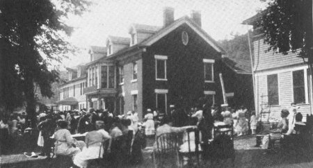 |
Montgomery County Farmers' Picnic.
At the Montgomery County Home farm, formerly the Schenck homestead, built
1835. Seen from Central Railroad and Mohawk Turnpike. |
Canowarode (1634) , Canajorha (1666-1693) on Schenck's Hollow Creek.
Two miles west of Yosts, the Can-a-jor-ha creek enters the Mohawk, directly opposite the
Little Nose on the south shore. Here the river landscape is very beautiful. The picturesque gully through
which the Canajorha runs is known as Schenck's Hollow and the creek is also called Schenck's Hollow creek, from
the Schenck family who here built, in 1835, the house which is now the main building of the Montgomery County Home.
Canajorha creek is sometimes called the Knauderack.
This place is the scene of the Montgomery county farmers' annual picnic, yearly attended by
thousands. The Home has a model farm.
A small Mohawk village of 19 houses, known as Can-a-wa-ro-de, in 1634 was located on a site now
occupied by the county home buildings.
On the Canajorha, two miles north of the river here, the Mohawk castle of Can-a-jor-ha was located
from 1668 until 1693, when it was destroyed in the bloody and destructive French-Canadian raid of that year.
Canajorha was on the (1920) Rice farm.
At present Schenck's Hollow, Major Fonda had here a house and mills, which were burned by
Johnson's savage white and red raiders on May 21, 1780, during the Revolution, when this was the fartherest
western point reached in their foray along the present Turnpike. (See Fonda and
Johnstown.)
In the old Turnpike days (1800-1850) a tollgate was located here at Schenck's Hollow.
The Schenck home was built on the site of Fonda's house, about 1835. This was the home of Martin
Schenck, State engineer, who, in his annual report of 1892, presented the first concrete plan for a Mohawk river
waterway along the lines of the present Barge canal.
A Haunt of Rattlesnakes.
The wild rocky glen through which the Canajorha runs has the unenviable reputation of being one
of the haunts of the dreaded rattlesnake and these reptiles are killed here each summer, some on the old Mohawk
Turnpike. This is all the more remarkable as the country all about here is free from poisonous reptiles.. In 1915
one was killed by an automobilist on the Mohawk Turnpike having sixteen rattles on its tail.
In 1921 two rattlers were killed, seven feet in length, one with ten and the other with thirteen
rattles. In 1922 one was killed having eleven buttons, close to the Yosts railroad pumping station. Big Nose
Ridge is a habitat of the rattlers. This hollow is on its western side.
Wild Animals of the Mohawk.
There is no recorded case of a person having been bitten by rattlers hereabouts in many years,
although occasionally a cow or dog suffers. Near the North Nose a Canadian lynx was shot in 1916. The wild country
of the Adirondacks runs close down to the river here - in fact crosses it at the Noses. Deer are frequently and bear
occasionally seen in the country a few miles north of the Mohawk, having strayed from the great Adirondack wilderness
into the cultivated uplands.
The Mohawk Dutch.
Before the Revolution the Dutch had generally settled the Mohawk valley east of the Noses and the
Palatine Germans, the valley west of here. They were known as the "Mohawk Dutch" and considerably intermingled.
Together with some British settlers they formed the white pre-Revolutionary population of the Mohawk valley which
then may have numbered about 15,000 as compared with a half million in 1920. the Low Dutch and the German speech
were generally spoken along the Mohawk until about 1840. "Mohawk Dutch" is a puzzle to linguists not raised on
the Mohawk. It is said to be a combination of the Holland Dutch, German and Mohawk languages.
Mohawk River Farms 200 Years in Some Families.
The Mohawk river farming lands from Schenectady to Utica are (1920) largely occupied by
descendants of the first Holland Dutch and German settlers, here located prior to the Revolution, in some
instances the same families being located on the same farms for two centuries or more. It is doubtful if
any other American locality shows such permanency of occupation. After the Revolution an influx of settlers
(from New England and elsewhere) located back from the river as the river section was occupied by the Mohawk
Dutch except in the western Mohawk valley, where they took up the original lands of the wilderness close to the
Turnpike.
Oswegatchie Indian Village.
A village of 3,000 Catholic Oswegatchie Indians was located at La Presentation (Ogdensburg) in
1748, controlled by Father Picquet. In 1763 all but 400 died of smallpox, a disease most fatal to Indians. Sir
William Johnson settled the survivors of the Oswegatchie tribe, probably where the section of Palatine called
McKinley is now located. The neighborhood has since been locally called Swe-gau-chy. This locality is 1-1/4
miles north of the Turnpike, opposite Sprakers. Following the turmoil of the Revolution (1775-1783) the remnant
of the once powerful Oswegatchie tribe was settled at the St. Regis reservatin on the St. Lawrence.
Tha-yen-dak-hi-ke, 480 Feet Above the Mohawk.
There is a strong contrast between the river's shores between the Montgomery County Farm, at
Schenck's Hollow, and Palatine Bridge. The north side cliff of Thayendakhike rises to a height of 480 feet above
the Mohawk, just west of the County Farm, and about one-half mile west, forms a rocky cliff rising 300 feet above
the river. The south shore has fertile farmlands sloping gently southward from the Mohawk flats in most places.
The beauty of the Noses and their river flats is unexcelled by the landscape anywhere along the Mohawk.
|