|
CANAJOHARIE - PALATINE BRIDGE.
continued.
(Montgomery County)
Return to Part I
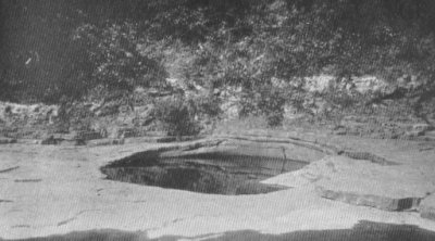
Canajoharie, "the Pot That Washes Itself."
At the western village limits of Canajoharie, the creek flows from its
picturesque gorge. A short distance above is located a giant pot hole,
about ten feet in width, worn by the action of water and pebbles in the
limestone bed. This is the original Canajoharie, which Brant, the Mohawk
chieftain, defined as meaning "the pot that washes itself." The
Iroquois (like all Indians) had a keen eye for unusual landscape features
and this curious "Canajoharie" gave its name not only to the
stream, but to at least four of their castles (of different periods and
different locations) and to the entire river district from the Noses
(between Sprakers and Yosts) to Fall Hill (east of Little Falls).
The name Can-a-jo-ha-rie, has also been translated as "the boiling
pot."
The Canajoharie is remarkable for its salt spring, its remarkable
mineral springs, its gorge and falls and its unique pothole.
Because the name Canajoharie was applied to so many points in this
section, the loose use of the name has given rise to many historical
errors. In Revolutionary times the Canajoharie was known as Bowman's
creek.
Canajoharie Shale and Mohawk Valley Geology.
The general rock outcrops in the Mohawk valley are as follows: The
Clinton sandstone and limestone cap the western Mohawk - Susquehanna
divide, while the Helderberg limestone caps the eastern valley watershed
rim (except the Schoharie valley). The Clinton sandstone and limestone
occupy the southern Oneida county section. The southern Mohawk river shore
section is generally of Ordovicic shales (Canajoharie, Utica and
Frankfort). The northern river shore is generally of Ordovicic shales and
the Trenton series limestones. The northern valley has the Adirondack
pre-Cambric surface rocks. From north to south, Schoharie county has the
Helderberg limestones, the Hamilton shales and limestones and the Devonic
rocks of the Catskill region, where at Gilboa, Schoharie county, the
oldest fossil trees in the world were found in 1869, now on exhibition in
the New York State Museum, Education Building, Albany.
Shaper Pond or Quarry, Where the Brooklyn Bridge stone
was Quarried.
On West hill, Canajoharie, is a stone quarry, known as Shaper's Pond,
because it is unused and is now filled with clear spring water, making it
a picturesque pond in summer and a good skating rink in winter. It might
well be called "Brooklyn Bridge Pond," because here was quarried
the stone which was used in the building of the Brooklyn bridge; this
stone having been shipped from Canajoharie to Brooklyn by Erie canal
boats. Much early Erie canal construction and the stone used in building
many famous New York city buildings, of the middle nineteenth century,
were taken from the Shaper Quarry, which has been unworked since about
1900. The stone is a calciferous sandrock of the Lower Silurian era,
belonging generally to the Trenton limestone period. It is known locally
as limestone. This fine building stone has outcrops on the north side, as
at Frey's Quarry, and many of the old Colonial stone houses of this valley
section - such as the Van Alstyne House (1750) in Canajoharie and Ft. Frey
(1739) in Palatine Bridge, were built of it, as well as the later houses
and buildings of Canajoharie. It merits a general use for house and
building construction today - in fact, Canajoharians are proud of this
splendid stone and of their fine stone buildings, which give their town an
architectural distinction above most other valley towns.
Canajoharie -- Historical.
In 1634 the Mohawk castle of Canagere was located to the east of
present Canajoharie, while, between here and Fort Plain on the south shore
the tribe had its middle castle of Sochanidisse. There was a small group
of Mohawk cabins on the banks of the creek here when the site of present
Canajoharie was settled about 1730.
Hendrick Frey, 1689 -- First Settler in the Middle
Valley.
Hendrick Frey, a Swiss, came up the Mohawk in 1689, made friends with
and bought lands of the Mohawk Indians and settled in present Palatine
Bridge, where he built a log house. He was an intrepid pioneer who located
in a wild, unbroken wilderness, peopled by savage red men and the wild
animals of the Adirondacks. The nearest settlements were those of the
Holland-Dutch in the Schenectady neighborhood, thirty miles eastward. Frey
was an Indian trader and "kept store" in his log cabin, as did
his grandson, in Fort Frey, which was also a famous frontier general
store. A ferry was located here across the Mohawk and during the Colonial
and Revolutionary period Palatine Bridge was known as "Frey's."
Fort Frey -- 1689-1739.
Just north of Palatine Bridge and a few yards north of the railroad in
an open field, stands Fort Frey, a quaint stone house built in 1739, on
the site where Hendrick Frey located in the wilderness in 1689. This is a
typical Mohawk valley house of the time. It suggests vividly the times
when the hardy Mohawk Dutch farmers, clad in buckskin and homespun and
with guns, bayonets and knapsacks, gathered here and at scores of other
vicinity centers on the alarm of "To arms, to arms," given by
some neighborhood rider. The Frey property is still held by the Frey
family (1924). For a time Fort Frey was palisaded and garrisoned by
British troops during the French and Indian war of 1701-1713, known as
Queen Anne's war. The history of this interesting house is practically the
history of civilization along the middle Mohawk valley.
The Queen Anne's War fort here located, consisted of the first Frey log
house palisaded and fortified. Present Fort Frey, erected in 1739, was a
British army post, at least during the early part of the French-Indian war
of 1754-1760. Both the Fort Frey and the present Frey mansion are built of
the native calciferous sandrock, which outcrops at the Frey Quarry here
and at the Shaper Quarry on West hill, Canajoharie. The old fort has an
interesting cellar, with strong stone fireplaces, which well served the
Freys of Colonial and Revolutionary days in the mighty cold winters of the
pioneer days in the wilderness for those hardy pioneers lived much of the
rime in the cellars of their stone houses during the worst of the winter,
or, as one of their descendants puts it, "they would not have lived
at all." Present stone Fort Frey is loopholed for defense.
The name fort applied here has been questioned but as it is the site of
an earlier fort and probably had such use later, as aforementioned, the
term is justified.
Major John Frey (1740-1833) was a member and chairman of the Tryon
County Committee of Safety and major of the Palatine regiment of the Tryon
county brigade of American militia. He fought at Oriskany where he was
captured by the enemy and, as a captive, narrowly escaped death at the
hands of the Indians and his own Tory brother who fought on the enemy
side. Major Frey succeeded the Tory White as the sheriff of Tryon county
under American rule. The major was a historian and assisted Campbell in
the preparation of "Annals of Tryon County," published 1831,
which was the first Mohawk valley history. Major Frey was born in Fort
Frey in 1740 and died in the Frey (1808) mansion in 1833 at the age of 93,
he being one of the last surviving Revolutionary Mohawk valley officers.
A World War Post.
During the World war, New York Guardsmen occupied (1917) Fort Frey for
a time, while guarding the Barge canal here. The Frey property today is in
the possession of the seventh generation from Hendrick Frey, who located
(1689) here, 235 years prior to this writing (1924). Mr. S. Ludlow Frey,
here resident in 1924, is a historian who has been the valley's greatest
authority on Mohawk Indian history. With General John S. Clark, he has
done a great work in studying and locating Mohawk village sites in the
valley.
Frey Homestead, 1808.
The larger stone Frey house was built in 1808. However it is a true
type of Colonial architecture and one of the Mohawk river's most
interesting homesteads. It stands on a sightly river slope in a grove of
locust trees to the west of Fort Frey.
The King's Highway, 1739.
Fort Frey stands close to the Central railroad because, when it was
built in 1739, the King's Highway from Palatine Bridge to near St.
Johnsville generally followed the present railroad bed. In later turnpike
construction, this section of the Mohawk turnpike was located as at
present, on higher ground eastward from the railroad.
Hendrick Schrembling, Canajoharie's First Settler, 1730.
About 1730, Hendrick Schrembling, a Palatine German, and Marte Janse
Van Alstyne bought of Cadwallader Colden 775 acres at Canajoharie.
Schrembling settled on the east side of the creek, while his brothers,
George and John, located on the west bank. In 1750 Schrembling sold the
east side property to his partner, Van Alstyne, who then came to live
here. Schrembling moved to the west bank farm, where he kept a tavern,
store and mill. The Schremblings left Canajoharie and the Valley at the
close of the Revolution.
Gose Van Alstyne built another grist mill on the creek about 1760. Col.
Hendrick Frey built a grist mill and a house here about 1772 and the Van
Alstyne, Schrembling and Frey families were the residents here prior to
the Revolution. In 1778 Johannes Roof came to Canajoharie and bought out
Schrembling and conducted the inn. He had lived at Ft. Stanwix, where his
property was burned during the seige of the fort in 1777.
About 1775, Gose Van Alstyne, son of Martin Jan Van Alstyne, built a
stone house near the present (1924) Martin Smith house on Front street.
This was stockaded about 1780 and became Fort Van Alstyne of the
Revolution, with which the Van Alstyne house of today has been frequently
confused. After the Revolution the Gose Van Alstyne house was torn down
and its stone used for the building material, some of which is said to
have been used in the present Hayes house.
 |
|
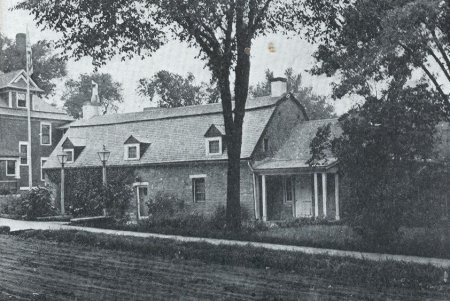
Van Alstyne House, 1750.
Built by Marten Janse Van Alstyne. The favorite meeting place
of
the Tryon County Revolutionary Committee of Safety. Washington
stopped here in 1783. Now the home of the Fort Rensselaer Club. |
The Van Alstyne House, 1750 --
Meeting Place of the Tryon County Committee of Safety.
During the Revolution Marte Jans Van Alstyne here lived in the Van
Alstyne house, which he had built in 1750. It was not palisaded but must
have been considered as a strong defense otherwise even its central Mohawk
valley location would not have made it the favorite meeting place of the
Tryon County Committee of Safety, which is known to have here held 16
meetings. Fort Frey, across the river, was not palisaded but it also was
considered a strong defense and both were never attacked.
As related later, General Washington reached Canajoharie August 1,
1783, and here he was a guest at the Van Alstyne house of Col. Clyde and
Mrs. Clyde, as well as of the Van Alstynes. The General and his staff took
dinner here and some of them also lodged here - as many as the house could
accommodate. This is one of perhaps four valley houses now standing which
were visited by Washington on this trip. The others were probably the
Shoemaker house in Mohawk, the General Herkimer house at Fall Hill and the
Volkert Vrooman house at Randall. General Washington also visited Fort
Herkimer Church.
Many distinguished men and women of Colonial, Revolutionary and
American days have visited the Van Alstyne house. Among them was the Irish
poet, Tom Moore, who stopped here on a trip from Canada to New York. He is
said to have here begun his famous poem, with the following opening lines:
From rise of morn till set of sun,
I've seen the mighty Mohawk run.
Moore continued writing the verses on board a river boat in which he
made the trip from Canajoharie to Schenectady, where he finished the poem.
Another version is that Moore wrote this poem at Cohoes Falls.
A handsome ball room stone addition has been built on the rear of the
house, in harmony with the architecture and masonry of the original
structure. The Fort Rensselaer club has furnished the place in Colonial
style and it is one of the most artistically appointed club houses on the
New York to Buffalo highway. It houses interesting historical collections
and the nucleus of a splendid art gallery. Besides the painting of
Washington by Stuart, here is a series of paintings by Wyeth illustrating
Stevenson's "Treasure Island," all of these works of art being
the gift of Mr. Bartlett Arkell.
Canajoharie and Palatine Districts of Tryon County,
1772.
The Mohawks called the river region between the Noses and Fall Hill
(present Little Falls) by the name of Canajoharie and so did the pioneers
from 1662 until 1772, the year of the formation of Tryon county.
When the great county of Tryon was created, in 1772, it was divided
into five districts. From the present Schenectady county line westward to
the Noses was called the Mohawk district, including in it Fort Hunter,
Johnstown, Caughnawaga.
Between the Noses and Fall Hill the region south of the Mohawk was
created the Canajoharie district and that on the north shore, the Palatine
district. West of Fall Hill, the south shore settlements became the German
Flatts district and the north shore the Kingsland district. These
districts continued during the Revolution and the creation of the
Canajoharie district has caused much historical confusion. (See
Johnstown.)
At the beginning of the Revolution, the houses hereabout suited for
defense were Fort Ehle (one mile south of Canajoharie), the Van Alstyne
house, Fort Frey and Fort Keyser, north of Palatine Bridge. All were stone
houses and formed a refuge for neighbors in time of valley raids.
1779 -- Gen. Clinton's Army at Canajoharie -- Portage
March to Otsego Lake.
In 1779 Gen. Washington directed that an American expedition be sent
against the Iroquois country on account of the outrages committed by these
Indians along the New York and Pennsylvania frontiers - particularly at
Wyoming, Pa., and Cherry Valley, N.Y. The army was under the command of
Gen. Sullivan and Gen. James Clinton was directed to proceed up the Mohawk
river with the New York detachment of the army (1,500 men) and cross over
to the headwaters of the Susquehanna and down that river, combine with
Sullivan's army and together march against the Iroquois. Clinton's men
assembled at Schenectady and marched up the Mohawk to Canajoharie. Gen.
Clinton (June 17, 1779) left the Mohawk and marched across country to
Otsego lake, about 25 miles, carrying his 200 bateaux and supplies on
carts and wagons. Clinton and Sullivan's American armies combined and
decisively defeated Indians and Tories near Elmira, August 29, 1779, after
which the Americans thoroughly devastated the country of the Six Nations.
At Canajoharie, on Academy hill, two Tory spies, Lieut. Newberry and
Sergt. Hare, were hung by Gen. Clinton's orders, in spite of the pleas of
their wives for mercy. Both men had been guilty of atrocities in Mohawk
valley warfare and their fate was well-merited. The capture of Sergt. Hare
by a fifteen-year-old Revolutionary "boy scout," Francis Putman,
is mentioned elsewhere, under Amsterdam.
Clinton's army consisted of the 3rd, 4th, 5th, (with artillery) N.Y.,
4th Penn., 6th Mass. Line (regulars) regiments, with a force of Tryon
County and Schenectady militia, attached to the 3rd N.Y. The center 3rd
N.Y. (Col. Gansevoort) and 4th Penn. (Lt. Col. Wm Butler) convoyed the
wagon train, consisting of 220 batteaux loaded on eight horse team wagons
and oxcarts, and other supply wagons, on the 25 mile portage from the
Mohawk at Canajoharie to Otsego lake. The 4th N. Y. (Col. Weissenfels)
formed the left wing. The 5th N.Y. (Col. Dubois), with artillery, formed
the right wing and was deployed over the Otsquago Trail near Summit (Mud)
lake to guard the center from expected attack from the west (See Fort
Plain.) The 6th Mass. (Major Whiting) marched from its post at Cherry
Valley to the lake. Camps were made on the march at Buel, Sprout Brook,
Starkville, Browns Hollow and Springfield. Gen. Clinton reached the head
of Otsego lake , July 2, and on the 4th of July, 1779, all the American
troops there camped held a great celebration of the third Independence
day. Clinton dammed the lake outlet and the expedition sailed in its
batteaux and marched down the Susquehanna, Aug. 9, 1779, and joined Gen.
Sullivan at Tioga, Aug. 22.
John Fea, the Amsterdam historian, who has made a fifty-year study of
this portage - one of the most remarkable American army feats of the
Revolution - says that the center went from Canajoharie over the Happy
Hollow road, the left wing over the Cherry Valley road (built 1773) and
the right wing over the Otsquago Trail. All these roads were then in
existence and only short stretches were cut and made by the troops. The
3rd N.Y. was camped on the flats at Canajoharie and the 4th Penn. on the
flats between the 3rd and the Happy Hollow road. Regiments numbered about
250 each. Clinton's force on the portage numbered about 2,000, including
batteaux men, artificers and about 200 Mohawk Valley farmers, who with
their horses and oxen assisted in this historic and famous portage march.
A monument in the Canajoharie public square marks the beginning of
Clinton's wilderness march. It was erected by Canajoharie Chapter,
Daughters of the American Revolution.
Currytown Massacre and Battle of Sharon Springs, 1781.
Currytown is a little hamlet about five miles southeast of Canajoharie,
which was the scene of an Indian-Tory massacre, July 9, 1781. The valley
American troops from Fort Plain pursued the enemy and routed them at the
Battle of Sharon Springs, July 10, 1781. A little boy named Devendorf, was
scalped by the Indians that day, but recovered and lived for seventy years
after. There were numerous instances of people scalped hereabouts who
survived thereafter many years.
Washington at Canajoharie and the Van Alstyne House,
Aug. 1, 1783.
In the summer of 1783, Gen. Washington made a tour of the Mohawk
valley, with a military escort, westward from Schenectady to the site of
Fort Stanwix (burned 1781), at present Rome. Washington made this trip in
connection with one to Crown Point and the battlefields where Burgoyne and
the British cause met defeat. In a letter to Gen. Schuyler, Washington
writes of this trip as:
"A tour to reconnoitre those places where the most remarkable
posts were established and the ground which became famous by being the
theatre of action in 1777. On our return from thence, we propose to pass
across the Mohawk river, in order to have a view of that tract of country,
which is so much celebrated for the fertility of its soil and the beauty
of its situation."
General Washington went west to Fort Stanwix from Schenectady, probably
following the Mohawk Turnpike on the north shore, a great part of the way.
On his return east, Washington dined at Fort Plain (Fort Rensselaer) July
31, and, in the afternoon, rode to Cherry Valley where he spent the night.
On August 1, the party rode to Otsego lake and, from thence, passed
over the route taken by Gen. Clinton's army in his Canajoharie-Otsego
march of 1779. Col. Clyde then commanded Fort Plain (officially known as
Fort Rensselaer). At the close of hostilities he brought his family up to
Canajoharie and installed them in the Van Alstyne house. Here Gen.
Washington and his staff dined with Col. and Mrs. Clyde on the evening
of August 1, 1783, and here the General remained over night, while his
staff took quarters in the Roof tavern. On August 2, Washington and his
party rode eastward down the valley. Nowhere, except at Canajoharie,
Cherry Valley and Fort Plain, have we any detailed record of this valley
trip.
At all valley points people gathered to greet their national hero. At
Canajoharie Washington is said to have addressed the crowd from a store
near Roof's tavern, and later is said to have patted the head of a little
negro boy. An eye witness says that this kindly act so displeased some
"prideful whites" that they left the scene in disgust. From
Albany Washington returned by boat on the Hudson to Newburg.
Washington regarded this tour as most important and wrote to the
Congressional president concerning it. He paid particular attention to the
Mohawk river-Wood creek route and the possibilities of its water
transportation, as well as the "portage between that [Otsego] lake
and the Mohawk river at Canajoharie."
Canajoharie - Palatine Bridge, 1783-1920.
After the Revolution the settlement here, known as Roof's village, and
also as Canajoharie, numbered about a dozen houses.
The first merchants to settle in Canajoharie after the Revolution were
the Kane brothers, who located in the Van Alstyne house about 1790, later
removing to Van Alstyne's ferry, one mile east. Others soon followed.
Historical Canajoharie dates of interest follow:
In 1790, first turnpike mail stages run from Albany through Schenectady
and Johnstown to Canajoharie; later extended to Utica and Geneva. 1800,
Great Western Turnpike (parallel route to Mohawk Turnpike, 10 to 15 miles
south) connects at Canajoharie with Turnpike stages. 1800, about 12 houses
here. 1803, bridge built across Mohawk. 1817-1825, Erie canal construction
booms village. 1818, Union (first) church built. 1829, village
incorporated. 1859, manufacture of paper bags begun by James Arkell. 1867,
Palatine Bridge incorporated as a village. 1882, West Shore railroad line
run through Canajoharie business section. 1890, food packing industry
started. 1916, silk industry started in Palatine Bridge.
Susan B. Anthony, the Great Suffragist, a Teacher in
Canajoharie Academy in 1848.
In 1848, Susan B. Anthony, the later suffrage leader, was a preceptress
or lady principal and teacher in Canajoharie Academy. In the history of
women's suffrage, Canajoharie takes a prominent place as it was, while
living here in Canajoharie, that Miss Anthony became interested in the
anti-slavery cause and later in that of women's political rights. Susan B.
Anthony finally gave up teaching in 1850, left Canajoharie and joined
Elizabeth Cady Stanton at her home in Seneca Falls, where Mrs. Stanton was
already advocating women's suffrage. Together these two intellectual
leaders made a strong plea for their cause, which might not have succeeded
without their united strength. As Elizabeth Cady Stanton was a native of
Johnstown and there developed her ideas of women's political and legal
rights, and, as Miss Anthony became interested in the same subjects here
in Canajoharie - the Mohawk valley may be truly said to be the cradle of
the cause of women's suffrage and of women's political rights- progressive
politics and political ideals which have become the political creed of
women the world around. (See Elizabeth Cady Stanton under Johnstown.)
Miss Anthony was born in 1820 and died in 1906, aged 86 years, at a
time when many of the western states had adopted women's suffrage.
Canajoharie - Palatine Bridge in 1840.
In 1840, Canajoharie is described as follows: "The village is
situated on the south side of Mohawk river. Incorporated in 1829. It has 4
churches - 1 Presbyterian, 1 Dutch Reformed, 1 Lutheran and 1 Methodist -
an academy, 10 stores, 2 grist mills, 2 distilleries, 1 brewery, 1
furnace, 2 saw mills. It furnishes fine stone for building and for the
construction of locks in the Erie canal. The Erie canal passes through the
center of the village. The Catskill and Canajoharie railroad will
terminate here." No population is given but about 800 in Canajoharie
and 1,000 in Canajoharie-Palatine are indicated. In 1840 Palatine Bridge
is thus described as being "opposite the village of Canajoharie with
which it is connected by a bridge. It contains 1 church, 3 stores, 30
dwellings and about 200 inhabitants. Here is a fine quarry of building
stone."
Webster Wagner's Sleeping and Parlor Car Inventions,
1858.
Palatine Bridge was the home of Webster Wagner (1817-1882) , a
prominent railroad man of the mid-nineteenth century. Mr. Wagner manufactured one of the first practicable sleeping
cars made in America. In
1858 Mr. Wagner formed a company and four cars were produced, which began
running over the New York Central railroad, Sept. 1, 1858. Finding the
cars' occupants suffered from defective and insufficient ventilation, Mr.
Wagner in 1859, invented the elevated car roof, placing ventilators in the
elevation. This invention which has worked so much for the benefit and
comfort of the traveling public, has had a general and world-wide
adoption. This same traveling public should gratefully think of its
benefactor. In 1867 Wagner produced the first drawing room coach or palace
car. Pullman introduced a similar type in Europe and about 1890 the two
companies producing the Wagner and Pullman cars were merged into one
concern under the name of the Pullman Palace Car Co.
Hon. Webster Wagner (State Senator from this district) was burned to
death in one of his palace cars in the Spuyten Duyvil railroad accident of
1882.
In 1878 Senator Wagner built the Wager House in Canajoharie, one of the
first modern hotels in the Mohawk valley.
Wagner and Schenck.
It is remarkable that Palatine Bridge is so closely connected with the
beginning of Central freight traffic and also with two men so vitally
identified with transportation interests -- Webster Wagner and Martin
Schenck. Wagner's work was for the promotion of the comfort and
convenience of railroad travelers, while Schenck's Barge canal plan has
untold future possibilities for the movement of heavy freight. Webster
Wagner was born near Palatine Bridge, while Martin Schenck was born in the
Schenck homestead four miles east, and the lives of both men were spent
largely in this locality. Schenck was State Engineer in 1892, when he made
his Barge canal plans public in his annual report.
Birth of New York Central Freight Traffic, 1836.
In the fall of 1836 (the year of the opening of the Utica &
Schenectady railroad) the freight business of the New York Central had its
inception at Palatine Bridge.
At this time the idea of carrying freight was not entertained. The
charter forbade it, consequently no preparations for the transmission of
merchandise had been made by the company. The desire of the superintendent
seemed to be to confine the business of the road to the carrying of
passengers. The occasion for handling freight, however, of course, arose
on the closing of the canal in 1836. On the very day that frost stopped
navigation in that year, a German family, wishing to convey their effects
from Palatine Bridge to Schenectady, were permitted to ship them on a car,
and this, it may be said, was the beginning of the way freight business of
the Central railroad. The conductor in this case, having no tariff of
rates to guide him, made the rather exorbitant charge of $14. The
legislature, in 1837, authorized the company to carry freight and
subsequently made the regulation, allowing passengers to have a specified
amount of baggage carried free of charge. The first freight cars were
called "stage wagons."
May 18, 1914, a "test" train of 125 freight cars passed up
the Mohawk valley over New York Central R.R. Up to that date this was the
longest train which had passed over this road, it being nearly a mile in
length.
Sochanidisse, Middle Mohawk Castle of 1634.
On the southern Mohawk shore, in the Happy Hollow section a mile of so
west of Canajoharie, on a high hill overlooking the river, the Mohawks had
their castle of Soch-an-i-dis-se in 1634. This was their great middle
castle and had 32 houses. John Fox, the historian, locates Sochanidisse on
the Brown farm. All the high ground between Happy Hollow brook westward to
Prospect hill, Fort Plain, was called Tsi-dros-o-wen-gen by the Mohawks
and the Hog's Back by the white settlers. It is thickly covered with
Mohawk remains, indicating a considerable Indian population and long
occupancy. Near here the Mohawks had a pow wow place which the Dutch
pioneers called de Danskammer (the dance chamber), where the Indians held
their savage rites and wild dances.
Van Slyck Patent, 1716.
In 1716, Capt. Harmanus Van Slyck of Schenectady was granted, by the
Mohawks, all the land bordering the north bank of the river, from the Big
(or Anthony's) Nose westward to the present eastern limits of the village
of Nelliston, a distance of seven miles. This grant was made because of
Van Slyck's Mohawk Indian relationship, his grandfather, Cornelisse
Antonsen Van Slyck, having traded near here and married a Mohawk woman
abut 1640. Harmanus located on the river over a mile west of the
Canajoharie-Palatine Bridge Central station where hebuilt a house and saw
mill. Only a foundation marks the site. His son, Major Harmanus Van Slyck,
was a prominent Revolutionary patriot and soldier.
DETOUR TO STONE ARABIA CHURCHES.
The tourist going west, can take a detour 4 miles north from Palatine
Bridge to the historic Stone Arabia churches. He can return to the Mohawk
Turnpike at Nelliston, 4 miles west from the churches.
On clear days the Cherry Valley mountains, 12 to 15 miles southward,
may be seen rising over a fertile farming plateau. The Stone Arabia
section. with its two interesting old churches, is historically most
important. As previously mentioned it was one of the first (1711)
locations of Palatine German settlement in America and it was an important
Revolutionary point.
The outcrop of the surface rock is the Trenton limestone in the river
sections of the Palatine township of Montgomery county, which covers the
old Stone Arabia section. The upland rock is Hudson river shale. The
Palatine township stone fences are noticeable features of the landscape
all through this section.
In the detour north, the tourist rises from a Mohawk Turnpike sea
elevation of 340 feet, to a sea elevation of 820 feet at the Stone Arabia
Reformed church, close to which Nelliston creek has its source.
|