|
UTICA, Part II.
(Continued)
Return to Utica, Part 1.
Masons' Auditorium - Utica, a Central Convention City.
The Masonic bodies of Utica contemplate the erection of an imposing auditorium with a seating capacity of 4,500. The
auditorium will be available within a reasonable time for use by conventions and other considerable gatherings in Utica. Because of this
auditorium, Utica's excellent hotel accommodations and the city's central location, Utica will surely eventually become a favorite
convention city for New York State.
Utica and Oneida County.
Utica is the county seat of Oneida county (formed 1798), which takes its name from the Iroquois tribe of Oneida
Indians, who occupied its territory on the Dutch occupation in 1614. The county contains much of the headwaters of the Mohawk river,
Black river, Oneida lake and three small headwaters of streams belonging to the Susquehanna system. Outside of the manufacturing
districts of Utica and Rome and some villages, the county is devoted to dairying and general agriculture. 1920 population Oneida
county, 154,157; 1920, 182,485; area, 1,215 square miles.
Utica, Historical - Indian Trail Center.
The old Indian path from Ya-nun-da-da-sis [the site of Utica] to Ga-na-wa-lo-ha-le [Oneida Castle] here intersected
the trail from Ska-na-tat [Schenectady] to De-o-wain-sta [the portage at present Rome]. Also from the river ford an Iroquois trail ran
north to the Oswegatchie [Black River] and thence to Canada, while to the south a trail led up Oriskany creek to the Chenango river
headwater stream of the great Susquehanna valley. This made Utica an Indian cross roads and as these trails developed into pioneer roads,
after the Revolution in 1783, this made the site of present Utica eventually an important transportation center which is the
original
cause of the city's early development. All the roads mentioned are now great motor car highways.
The Oneida Indians.
The crossing trails on the site of present Utica not only indicate the commanding commercial position occupied by
the present city but it symbolizes the strategic position occupied by the Five Nations on the Iroquois Trail (from Albany to Buffalo)
which enabled them to become masters of the Indians of northeastern North America.
Ya-nun-da-da-sis is an Oneida word meaning "around the hill," referring to the south shore Mohawk trail's course
around Dutch Hill to the east of the city. Ga-na-wa-lo-ha-le, meaning "head-on-a-pole," was the name of Oneida Castle, some twenty
miles westward. The site of Utica formed the eastern limits of the jurisdiction of the Oneida nation and the western limits of that
of the Mohawks.
In 1821 the greater part of the Oneidas were removed to Chippewa Bay, Wis.,
in spite of their protests. In 1910 there
were about 30 Oneida Indians living in Oneida county and about 200 in the State, some being in Madison county.
The city of Utica lies in land patent known as Cosby's patent or Cosby's manor, granted in 1734 and surveyed in 1762.
Old Fort Schuyler, 1758-60.
In 1758 British Colonial army engineers here built a fort, one of a chain of defenses which extended along the
Albany-Oswego water route during the great French war (1754-60). This local fort was an earthwork with palisades and it stood on Main
St., near the Mohawk river just below Second St.
This fort was christened Fort Schuyler, in honor of Col. Peter Schuyler of Albany, uncle of Gen. Philip Schuyler of the
Revolution. It was garrisoned from 1758 until 1760, when it was abandoned. When the American army reconstructed Fort Stanwix (at present
Rome) in 1776, its name was changed to Fort Schuyler in honor of Gen. Schuyler, which name it generally bore in army records until after
the Revolution. To differentiate between the Rome and the Utica Fort Schuylers, the Utica fort site was then referred to as Old Fort
Schuyler. The same name for the two forts has been the cause of endless historical confusion. After the Revolution (1775-1783) the
Rome fort resumed its name of Fort Stanwix, which is its present appelation.
The Fort Schuyler club of Utica takes its name from the Utica fort, which is now generally referred to as Fort
Schuyler, while the Rome fort is known as Fort Stanwix. This is based on the best historical authorities and also the usage of
convenience.
Settlement of Deerfield Corners, 1773.
In 1773, the Weaver, Reall and Damuth families settled present North Utica at Deerfield Corners. They were driven
out and their homes burned in 1776 by hostile Indians. They returned and settled permanently on their old lands in 1784, as stated
later.
General Herkimer's Crossing of the Mohawk, August 5, 1777.
General Herkimer and his American army of valley militia here at Utica crossed the Mohawk ford, August 5, 1777, from
the north to the south bank on his way to the battleground of Oriskany. The site is marked by a bronze tablet erected in 1912 by the
D. A. R. at the site of Old Fort Schuyler. (See Oriskany Battlefield Monument.)
General Herkimer's Camp, August 6, 1777.
After the Oriskany battle, August 6, 1777, the wounded Gen. Herkimer was brought by litter to Old Fort Schuyler, where
the little army of heroic American survivors made their night camp. Here he was put on a boat and that night he was rowed down the
Mohawk, 16 miles, to Fort Herkimer. Other wounded were taken down the valley the same way.
Lt. Col. Campbell and Major Samuel Clyde of Cherry Valley, commanded the retreat of the American army from Oriskany
down the Valley.
The Utica fort marker was one of a number erected by the Mohawk valley D. A. R. Chapters in 1912, marking Gen.
Herkimer's march to the Oriskany Battlefield. The markers are granite, with a relief inscription. At the top of each marker is a
bronze tablet showing in relief the route of Herkimer's march.
Great Western Migration Through Utica After 1783.
Following the Revolution's close, in 1783, the great westward migration began. A few settlers went along the Mohawk
roads in 1784 to homes in the upper Mohawk valley (in what is now Oneida county) and further west. In 1785 the flood tide began and the
next five or ten years witnessed the full flow of one of the most remarkable movements of people in the history of the world - that of
the American people themselves, largely through the Mohawk valley to new homes in the great west. The bulk of these migrating people were
New Englanders or "Yankees" and Oneida county was largely settled by them and by people from the British Isles, a large element being
Welsh which made their most important early location here at Utica.
The majority of Utica's early settlers were Yankees, English and Welsh, but many
pioneers of Dutch and German ancestry
from down the Mohawk located in Utica as well as in Oneida county. In fact, John Post, the first merchant of Utica, the present great
city of the western Mohawk Valley, removed from Schenectady here, the present great city of the eastern valley.
The Mohawk roads and river formed the summer route of the majority of settlers who went from the east to people the
west and in that season the river was dotted with their westward moving boats and the roads with their covered wagons or "prairie
schooners." However, winter was also a favorite moving time, as the snow smoothed out the rough roads, furnishing an easy journey on
sleighs. At Old Fort Schuyler (as Utica was called from 1785 until 1798) nearly all of this westward movement left the Mohawk over the
road to the Genesee country, to Lake Erie and the great west. Others turned north and peopled the Black River valley and northern New
York state.
Situated as it is at the western gateway of the Mohawk highlands, Utica is indeed a "gateway to the west," just as
Little Falls is the middle gate and Schenectady the eastern valley gateway.
Settlement of Utica (North Utica), 1784 - Old Fort Schuyler (Utica), 1785.
The first settlement within the limits of Utica was made in 1773, in present North Utica at Deerfield Corners, by
George J. Weaver, Mark Damuth and Christian Reall and their families. These were people of Palatine German ancestry from the German
Flats (Herkimer) neighborhood. Reall's creek takes its name from Christian Reall, whose house stood near it. These first settlers of
Utica were all Whigs or patriots. As they did not have, in their front yards, the Tory emblem of a horse's skull on a stake, they had to
flee to their old homes on the approach, in 1776, of a Tory and Indian raiding party, which burned their homes. All probably served in
the American armies. Damuth was a captain with Gen. Herkimer's army which marched to aid Fort Stanwix. Damuth, John Adam Helmer and
another unknown were the three scouts sent by Herkimer with dispatches for Gansevoort. Damuth was severely wounded in a later Valley
enemy raid and Weaver was taken a prisoner to Canada. In 1784 the three families again united on their farms and thus became the first
settlers of Utica. As these settlers plowed, planted and raised crops on their old lands (Jones Annal of Oneida County, pp. 141-142)
they merit attention as possible first settlers of Oneida county. They certainly were the first permanent settlers within the present
city limits of Utica. One of the Damuths was a first settler of the old Fort Schuyler section of Utica in 1785.
In 1786 there were log houses in present Utica, south of the Mohawk, of families by the names of Damuth, Cunningham
and Chrisman, all "upon or near the old road to Fort Stanwix, corresponding nearly with Main and Whitesboro streets," thus being at the
lower end of Genesee street.
In 1788 the town of Whitesboro was formed from the township of German Flats. Whitesboro then had 200 population and
embraced all of the state westward. Following 1786, new settlers by the names of Alverson, Morey, Foster and Silyea came to Utica.
John Post, Utica's First Merchant, 1790.
John Post, Utica's first merchant, can be justly considered the founder of the city. He came here and established a
trading post in 1790, previous to which time he had been a trader among the Iroquois, largely in ginseng root for export to China. Post
was born in Schenectady in 1748. He was an officer in the Revolutionary American army, serving on Gen. Gates' staff at Saratoga, on
Sullivan's expedition, at the battle of Monmouth and at Yorktown, when Cornwallis surrendered in 1781.
In the spring of 1790, having purchased land near Old Fort Schuyler, John Post removed from Schenectady to present
Utica. At Schenectady he loaded merchandise, furniture, provisions and building material on boats. With himself, his wife and children
and a carpenter as passenger and a crew of boatmen, he slowly came up the Mohawk, making the trip of 80 miles in nine days. "So deep was
the mud in the road, now Genesee street, that the children had to be carried to the big 'palace' previously erected. The persons then
residing here [1790] were Uriah Alverson, John Cunningham, John Christman and Widow Damuth and their families and probably some others."
Post erected a frame three-story warehouse on the river and later one near the Genesee street river bridge. Post
owned a fleet of Mohawk river boats which were engaged in transporting merchandise and in bringing settlers and their effects from
Schenectady to Utica. Three of these were Mohawk river packet boats, fitted with covers and seats, which carried passengers only,
this transportation being preferred by many to the stages on the rough river roads.
Post built a store and had an important trading post and business here until he was burned out in 1806, which disaster
ruined him and he died in poverty in 1830.
Settlers came rapidly to ld fort Schuyler after Post's settlement in 1790 and by 1795 there was a thriving busy little
village here with log and frame houses, stores, taverns and shops of various kinds.
In 1792 a bridge was built across the Mohawk, near First and Second streets, and a stage route was established
running from Albany and Schenectady to Utica and Whitestown. This route was extended westward over the Genesee road (later Seneca Road)
to Geneva in 1794.
First Mohawk Valley Newspaper, 1793.
In 1793 the first Mohawk valley newspaper was founded at the settlement of New Hartford, to the south, then a larger
settlement than Old Fort Schuyler. This was the Whitestown Gazette, which was removed to Utica later.
In 1793 the First Presbyterian church was organized. In 1801 the Welsh Presbyterians had a church here and Trinity
Episcopal church was begun.
River, bridge and highway improvements of 1797 boomed Utica, which became a great travel center by both routes. In
that year $2,200 was appropriated by the state for the improvement of the "great Genesee road" between "Old Fort Schuyler" and
Geneva. From this great road, its city section, Genesee street, takes its name. The same year a river bridge was erected at the foot
of Genesee street at a cost of $400.
 |
|
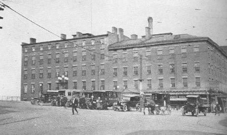
Baggs Hotel, Utica, 1813.
The oldest large hotel in New York state, continuously
open since Moses Bagg built the first log tavern here in
1797. Buses run to all points of the compass from Baggs
Square, on the west side of this famous old hotel. |
Utica Village, 1798.
In 1796 there were 35 houses here and in 1798, when the place was incorporated as a village, there were 50 houses, with
over 200 people here. The name of the place had been Old Fort Schuyler from 1758 to 1798. A number of prospective were suggested and
written on slips. The name drawn from these was that of Utica.
In 1797 the schoolhouse was enlarged, after which union church services were held herein.
In 1798, Moses Bagg, a blacksmith, opened the original Baggs Hotel. The present south end of the Baggs was
built (1813) around the first log structure without interruption to business and Baggs Hotel is probably the oldest large hotel, with a
continuous existence, in the United States.
In 1798 Oneida county was formed and, on April 3, 1798, Old Fort Schuyler was incorporated as a village with the name
of Utica. Utica and Whitestown were the county seats or "shire towns" until 1854, when Utica and Rome became the half shire towns with
court held at both places.
In 1804 Utica had 120 houses and buildings and had become an important little town with four tanneries, two nail
factories, two breweries, a hat factory, and a cabinet maker, watchmaker, potter, shoemaker, rope maker, besides other shops, stores,
taverns, two churches, a school house, barns and other buildings.
Seneca Road, 1800.
The building of the Genesee street river bridge in 1797, the improvement of the Mohawk Turnpike and the construction
of the Seneca Road (formerly the Genesee road) westward from Utica, both in 1800, "were among the first movements which gave Utica a
start and secured for it a share of the business heretofore monopolized by Rome and other places in this vicinity." The frontier village
of Utica grew rapidly thereafter.
Utica was the greatest national center of military movements in the War of 1812-14, many American troops passing
through the city to and from the Niagara and St. Lawrence frontiers. In 1817, Utica township was formed.
Erie Canal, 1819, 1825.
In 1817 Erie canal construction was begun and in 1819 the canal was completed to Utica and on Oct. 22, 1819, the
first boat "Chief Engineer" made the initial trip between Rome and Utica, when a great celebration was held. The opening of the Erie,
from Buffalo to Albany, in 1825, greatly stimulated the town.
In 1818 Utica Academy was built and the first public library was opened in 1825.
In 1827 slavery was abolished in New York state and the slavery abolition movement soon agitated Utica, like most
northern towns. The Abolitionists were few and despised at first but the movement, which excited much bitter
controversy, continues
until its objects succeeded in the Civil war (1861-5).
Utica City, 1832.
On Feb. 12, 1832, Utica was chartered a city. In the same year it suffered
considerably in a national cholera
epidemic. In 1835, the city had a population of 10,183, with considerable manufacturing. The population was 12,782 in 1840, with city
expenses of $11,734.96 in 1841. In 1845 with 14,000 people Utica had thirteen large and many small industries, with an annual
manufactured output of $236,811.
Utica in 1840.
In Haskells and Smith's U. S. Gazeteer of 1840, Utica is described as follows: "Utica, city, Oneida Co., N. Y., is
on the south side of the Mohawk river in 43 deg. 10 min. north latitude, 74 deg. 13 min. west longitude, 92 miles west by north Albany;
140 m. Rochester, 202 m. Buffalo, 76 m. Oswego. Pop. 1820, 2,972; 1830, 8,323; 1840, 12,782. The city stands on a beautifully inclined
plane rising south from the Mohawk, the highest parts of which present fine prospects. The buildings, most of which are of brick, are
good and many of them splendid. The streets are neat and spacious, many of them 100 feet wide. It has 18 churches - 3 Presbyterians,
1 Dutch Reformed, 2 Episcopal, 4 Baptist, 3 Methodist, 2 Roman Catholic, 1 Universalist, 1 African, 1 Friends meeting meeting house.
There is also an Exchange building. Besides numerous charitable institutions, there are in the city the County Medical Society, 2
incorporated academies, one for males and one for females, a museum, the Utica Library, the Mechanic's Association which supports popular
lectures, and the Apprentices Library. There are 4 banks with an aggregate capital of $900,000, besides a bank for savings and an
insurance company with a capital of $200,000 and a mutual insurance company.
"The State Lunatic Asylum is located here, about a mile west of the center of the city. The Erie canal, here widened
to 70 ft. and 7 ft. deep, passes through the central part of the city and is crossed by a number of elevated and elegant bridges. The
Chenango canal connects this place with Binghamton in Broome county. The Great Western Railroad from Albany passes through it. There
are also fine roads in various directions, north and south, on which numerous stages run. Utica is in the midst of a rich and highly
cultivated country and, as might be expected, possesses an extensive trade. A culvert has been completed within the city from the
canal to the river at an expense of $100,000. Utica was incorporated as a village in 1798 and as a city in 1832. There were, in 1840,
in the city, 2 commercial and 3 commission houses in foreign trade, capital $58,000; 188 retail stores, capital $1,678,595; 3 lumber
yards, capital $41,000; 5 furnaces, capital $50,000; value of machinery
manufactured $166,555; 6 tanneries, capital $103,000; 2
breweries, 1 flouring mill, 2 grist mills, 2 saw mills, 1 paper factory, 6 printing offices, 6 weekly newspapers, 61 brick and stone
and 30 wooden [the principal] houses, cost $253,000. Capital in manufacture, $496,130, 10 academies, 670 students, 36 schools, 981
scholars."
A considerable Irish and German influx into Utica began about this time.
Utica and Schenectady Railroad - Chenango Canal, 1836.
Utica citizens subscribed to $4,300,000 of the stock of the Utica & Schenectady Railroad, which was opened
August 1, 1836, and extended to Syracuse in 1839.
In 1836, the Chenango canal was opened northward from Chenango river headwaters of the Susquehanna, through the
Oriskany creek valley to Utica, forming a valley outlet for coal from Pennsylvania. This canal was abandoned in 1878. In the modern
utilization of trunk waterways, the use of the Chenango canal may be resumed as well as other abandoned waterways of New York state, the
pioneer and leading commonwealth in canalization.
In 1854, the Utica & Black River R. R. (now a New York Central line) was opened to Boonville and later extended
to Carthage. The Utica, Clinton & Binghamton railroad was opened to Hamilton in 1867. In 1883 the West Shore railroad (now a New
York Central line) began running through the southern city limits. In 1902 the trolley route was extended eastward to Little Falls.
In 1905 Barge canal construction was begun and completed from Waterford to Utica in 1916 and opened in 1918. In 1913, Harry Atwood, in
his flight from St. Louis to New York city, passed over Utica and down the Mohawk, and on June 3, 1924, the great U. S. naval dirigible
Shenandoah passed westward over the Mohawk Valley, on its way from New York to Buffalo, adding the final chapter in Utica's history of
transportation.
In 1848 the Utica water works and gas company were inaugurated. In 1851, the city hall was begun. In 1862 an armory
building was erected, and in 1893 the present armory took its place. In 1883 the Government building and the Y. M. C. A. were built.
Utica Industrial Growth.
The first great industrial development in the Utica metropolitan district was the beginning of cotton cloth manufacture
in 1804 at New York Mills, at the present western limits of Utica. For the first forty years of its growth, 1785-1825, Utica was chiefly
a trading and transportation center. Manufacturing followed the building of the Erie canal (here as elsewhere along the waterway) as it
furnished the first cheap transportation facilities. The first local industry of importance was the manufacture of plows begun in
1820. Local industries and the dates of their establishment follow: 1823, grist mill, iron foundry; 1826, pottery works; 1832, engine
and boiler works, oilcloth factory; 1834, steam planing mill; 1836, ready made clothing; 1842, stoves and furnaces; 1847,
woolen
goods; 1848, cotton cloth; 1851, locomotive headlights; 1852, iron
works; 1861, steam guages; 1862, firearms; 1863, knit goods;
1868, caps; 1886, worsted; 1890, burial caskets. Other industries have been added and are constantly coming to this increasingly
great industrial center.
A considerable Italian and Polish immigration to Utica marked the period from 1890 to 1920.
Utica, Civil War (1861-5), World War (1917-8)
Utica, as the county seat, was the center of Civil war activities of Oneida county. The principal military
organizations recruited from this and adjacent counties were 14th, 26th, 81st, 97th, 117th, 146th infantry regiments, the Oneida
cavalry and Oneida county had representatives in some twenty-five other Civil war commands.
Utica Armory, Headquarters 3rd Battalion, 10th Infantry, N. G. S. N. Y.
The Armory at Park avenue and Rutger street is the headquarters of the 3rd Battalion, 10th Infantry, National Guard
State of New York. the Utica units are Co. K , Co. L and Headquarters Company. Co. I , at Mohawk, is the champion marksmen company of
the National Guard of the United States. Co. M , machine gun company, is located at Hudson. In 1923 the Third Battalion of the Tenth
ranked third among the battalions of the State in point of efficiency.
Co. L was originally formed in 1837 as the Utica Citizens Corps, a famous military organization of its day. It
volunteered in a body for the Civil War and furnished the Union armies with six major generals and three brigadiers. It became the
44th Separate Company, New York Guard in 1887 and Co. E , 1st N.Y. Vol. Inf. during the Spanish -American War in 1898, when it did
guard duty in the U. S. and Hawaii.
Co. K was originally the Utica Fire Zouaves, which became, in 1873, Co. C , 26th Battalion, N. Y. N. G. As the
28th Separate Company it was recruited into Co. G , 203rd Regt. N. Y. S. Vols. during the Spanish -American War.
Cos. K and L members served in the 107th Infantry, 27th Division, in France, where their main action was in the
breaking of the Hindenberg Line near Bony, where they lost heavily. The record of the Utica military units is one of the finest in the
splendid record of America's citizen soldiery.
Troop G, 101st Cavalry, 27th division, N. G. S. N.
Y., as its armory on Lafayette street. Many of its members served
valiantly in the World War, when most of the Guard Cavalry units were transferred to machine gun companies.
The Lewis Machine Gun in Utica.
The World War was won in the arms and ammunition factories of America as well as upon the field. The Lewis machine
gun was a great asset in the military strength of Great Britain. It was manufactured in Utica in the Savage Arms Co., which attained
the remarkable monthly production of two-thirds of all the output of the factories of Great Britain and Canada combined. The rifle
factory of Ilion and the machine gun works of Utica were powerful factors in winning the war for America and her allies.
Utica, Political -
Gov. Seymour, Democratic Presidential Candidate, 1868.
The city of Utica was the home of Horatio Seymour, a brilliant public man who was a Democrat "war" governor (1862-4)
of the greatest patriotism. Seymour was an unsuccessful candidate for president of the United States in 1868, running against Gen.
Grant. Utica was the home of U. S. Senator Roscoe Conkling, the famous Republican politician of the latter nineteenth century, and of
U. S. Senator Francis Kernan, Democrat.
 |
|
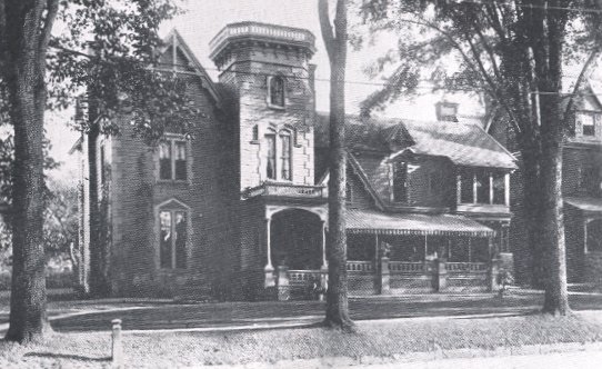
Vice-President Sherman Home.
Home of the late James S. Sherman, Vice-President of the United States,
1908-1912, on Genesee street, Utica. |
Vice President James S. Sherman, 1908-12.
A prominent political figure of Utica was James S. Sherman, who was for years a Republican Congressman, representing
the Utica district and who was elected vice president with William H. Taft on the republican ticket of 1908. Mr. Sherman was renominated
in 1912 on the Taft-Sherman Republican ticket, but died just before the election of President Wilson and Vice President Marshall,
Democrat. A statue of Vice President Sherman was erected here in 1923, and his house stands (1924) on Genesee street. Many other
nationally famous men have been residents of Utica.
President Grover Cleveland was a boyhood resident of Clinton and Holland Patent, Oneida county.
Utica is a modern, progressive American city with an interesting and important past and a promising future, due to
its past and present enterprising and patriotic American citizens and its wonderful industrial and commercial location.
For more detailed historical information on Utica, see Pomeroy Jones' "Annals of Oneida County;" Wager's "History of
Oneida County;" H. J. Cookinham's "History of Oneida County."
Utica and Mohawk Valley Temperatures and Rainfall.
The following figures cover the average monthly and annual temperature (covering a period of 47 years) at Utica. They
are furnished by the Weather Bureau at Washington,. While the figures refer to Utica, they also may well represent the Mohawk Valley,
particularly in this town and city section form Schenectady to Utica. From Little Falls east, the Middle and Lower Mohawk temperatures
are probably somewhat higher than those at Utica, but the difference is very slight. The Adirondack and Catskill (Schoharie) regions
probably vary more markedly.
The average monthly temperature records, taken at Utica (covering a period of 35
years) are as follows, in temperature
degrees:
January, 24; February, 24; March, 32; April, 44; May, 56; June, 65; July, 69; August, 68; September,
59; October, 47; November, 36; December, 26. Average annual temperature, 46.
The average monthly and yearly rainfall, taken at Utica during a period of 47 years, are given as follows, in inches
and their percentages:
January, 3.20; February, 2.95; March, 2.95; April, 2.70; May, 3.60; June, 4.15; July, 4.60; August,
3.65; September, 3.55; October, 3.45; November, 3.90; December, 3.35. Average annual rainfall, 42.05 inches.
The run from Utica to Clinton (9 m. s.) and Hamilton College is one of the most attractive of the many interesting
and beautiful drives which lead in all direction from Utica. The Utica city district embraces a section within a circle drawn ten
miles from the Utica City Hall, including the village of Clinton and Hamilton College on its western outskirts. On this route the tourist
passes New Hartford (settled 1788) , virtually a southern part of Utica. About two miles west of New Hartford the Seneca Road to Syracuse
and the west branches off from Genesee street. This route to Syracuse is described in the Summary in the front of this book. The
road from this point to Clinton is the most traveled highway in the Mohawk Valley west of Amsterdam, according to figures of 1922.
Clinton, nine miles south of Utica, is connected with it by trolley, the New York, Ontario and Western R. R., and by
highway, known up to Clinton as Genesee street. This road continues southward along Oriskany creek to Oriskany Falls, Hamilton (Colgate
University), Norwich to Binghamton. From Hamilton village it runs south along the Chenango river, a headwater stream of the
Susquehanna.
Clinton is an attractive residential town, many of its people commuting to business in Utica. A monument, on
the village green, marks its settlement by New Englanders in 1787. Clinton lies in a fertile farming country and has important
canning industries. Here are two iron mines, one on the north side of the town and the other southward at Franklin Springs. Only the
north side mine is (1924) worked, the product being used in the manufacture of metallic paint.
President Cleveland a Boyhood Resident of Clinton.
President Grover Cleveland was a boyhood resident of the villages of Clinton and Holland Patent, in Oneida
County, in both of which he attended school. His father was a Congregational minister, serving churches in Clinton and Holland
Patent.
 |
|
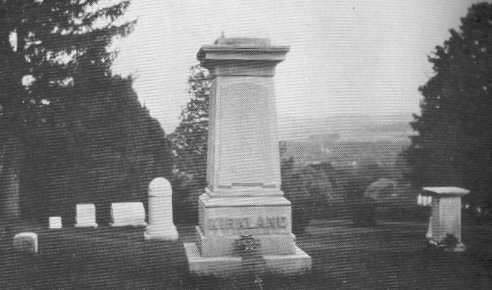
Kirkland and Sconondoa.
Monument to the Rev. Samuel Kirkland, missionary to the
Oneidas, chaplain in the Revolutionary armies and founder of
Hamilton College,
and Sconondoa, the great Oneida chief, in the
Hamilton College cemetery. The insignia of the Sons of the
American Revolution stands against
each monument. |
Hamilton College (1812), at Clinton.
Rev. Samuel Kirkland, a great American patriot and a missionary to the Oneida Indians, founded Hamilton College in 1794.
Kirkland went to the Senecas as a missionary in 1765 and to Oneida Castle in 1766, where he lived (except during the
Revolution) until he removed to the site of Hamilton College in 1791. Kirkland was beloved by the Oneidas and his influence kept the
majority of this nation on the side of the Colonies during the revolution. Sconondoa, the famous Oneida chief, loved Kirkland as a
brother. Dying at the age of 101, the great Oneida warrior requested that he be buried beside his white brother. Today, the visitor to
the College Cemetery can see the graves of Kirkland and Sconondoa, side by side. For his patriotic services to his country, Kirkland was
granted a plot of land two miles square in the present township of Kirkland. He set aside a portion of these lands for the use of an
academy for the Oneida tribe. Kirkland had won the regard of Washington and Hamilton, who became the first trustee of Hamilton Oneida
Academy, chartered by the Regents of the University of New York, Jan. 29, 1793. In a small clearing, at a spot just south of the present
Chapel (now marked by a tablet) the corner stone of the first building was laid by Baron Steuben, July 1, 1794. Kirkland died in 1808.
The school expanded until, in 1810, its students numbered 170, a very large attendance for the time and place. May 26, 1812, the college
charter was granted and it became henceforth Hamilton College.
Hamilton College numbers many famous Americans among it alumni and it has educated many Oneida county and Mohawk Valley
men. In 1922 Hamilton had a total registration of 321, with 57 from Oneida county. "In a period of rapid changes in educational theory,
Hamilton chooses to preserve the earlier college ideals."
The college occupies a natural plateau with a sea elevation of 900 ft., 500 ft. above the Mohawk and 300 above the
Oriskany on the east side of College Hill. The beautiful campus consists of a park of 95 acres, shaded by ancient trees. It has a splendid
prospect overlooking the picturesque Oriskany Valley and the wide sweeping stretches of the Mohawk slopes with Utica in the distance.
The college buildings are attractive architecturally and are all of stone, with the exception of two of brick. The
Chapel, built in 1828, and enlarged in 1897, occupies the center of the campus. It is a stone Colonial type of church, with a fine organ
and is adorned with memorial windows. Other main buildings are Root Hall of Science (1897), Chemical Laboratory (1903), Knox Hall (1885),
Benedict Hall of Languages (1897), Truax Hall of Philosophy (1900), Library (1914) with 100,000 volumes, Silliman Hall (1899), housing
the Y. M. C. A.; Soper Commons (1903) . Three dormitories, North College (1842), Carnegie College (1904) and South College (1906), Soper
Gymnasium (1891), Russell Sage building, housing a 220 yard running track and a playing field 85 by 200 feet, used as a rink for ice
hockey in winter, in which game Hamilton's students excel. The Steuben Athletic Field adjoins it.
The Museum of Natural History in
Knox Hall has large and valuable geological, mineralogical, biological and archeological (Indian) collections. A statue of Alexander
Hamilton graces the Chapel. A statue of Kirkland will probably be erected on the campus some day.
Hamilton's student body is limited to 400. The college attracts students who emulate the fine Americanism exemplified
in the lives of Kirkland and Hamilton.
Hon. Elihu Root (U.S. Sec'ty of War under President McKinley, Sec'ty of State under President Roosevelt, U.S. Senator)
was born here, both his father and brother being Hamilton professors. Mr. Root was (1924) chairman of the Hamilton trustees. The Root
residence faces the southern end of the campus.
Before Colgate University, at Hamilton village, assumed the present name, it was called Clinton College. Thus
there were then Hamilton College at Clinton and Clinton College at Hamilton.
A tablet, marking the Indian boundary of the Fort Stanwix treaty of 1768, stands on the College Hill road to
Clinton.
The fine, old (second), local residence of Rev. Samuel Kirkland, built in 1794, stands to the south of the foot
of College Hill.
RETURN TO SOUTH SHORE MOHAWK ROAD AT YORKVILLE.
(Oneida County)
(Over N.Y.C.R.R., N.Y., 240 m. ; Buffalo, 199 m. Sea elevation, 404 feet. 1920 Pop., 1,512).
Yorkville is an incorporated village, one mile east of Whitesboro, which lies on the west side of the Sauquoit,
opposite Yorkville, both towns being western suburbs of Utica. Yorkville adjoins Utica's western limits.
Sauquoit creek rises 12 m. s., airline distance from its outlet, near Paris Station. On it are several important
industrial communities, including New York Mills, where in 1808, the first cotton cloth made in the Utica district was manufactured.
|
